
| Working Temperature (°C) | From -10 to 40 |
|---|---|
| Weather Proof IP Rating | None |
| Max. ascent speed (km/h) | 28 |
|---|---|
| Max. descent speed (km/h) | 22 |
| Usage | Agricultre, Mapping and surveying |
| Drone Type | Quadcopter |
| Dimensions unfolded (mm) | 347,5×283×139,6 |
| Dimensions folded (mm) | 223×96,3×122,2 |
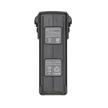
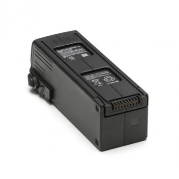
| Batteries number | 1 |
| Battery capacity / Battery weight | 5000 mAh / 335,5 gr |
| Navigation | BeiDou, GPS (L1/L2), Galileo (E1/E2), Glonass (L1/L2) |
| Redundancy & Sensors | Dual GNSS, Dual IMU |
| Flight control | Custom built-in |
| Remote controller | RC PRO Enterprise |
| Remote video output ports | HDMI, USB |
| Operating frequency | 2.4 GHz (CE <20 dBm), 5.7-5.8 GHz (CE <14 dBm) |
| Maximum distance | 15 Km. |
| Propeller model | 9453F |
| Obstacle avoidance | Bottom: 0.3 to 18m / 130° (front and back), 160° (left and right), Front : 0,5 to 200m / H : 90° V : 103, Height: 0.2 to 10m / 100° (front and back), 90° (left and right), Lateral : 0,5 to 25m / H : 90° V : 85 |
| Apps | DJI Pilot 2 (Android & iOS) |
| Motor model | 2008 |
| Max. altitude sea level (m) | 6000 |
| Max flight time (minutes) | 43 |
| Max. speed (km/h) | 76 |
| Max. take-off weight (kg) | 1.05 |
| Weight incl. batteries and propellers (kg) | 0.951 |
| Camera stabilisation | 3-axis (pitch, roll, yaw) |
|---|---|
| Angular vibration range in ° | 0.007 |
| Controllable range | Tilt: -90 to 35°; pano: -5° to 5 |
| Mechanical range | Tilt: +45º to -135º / Pan: ±100º |
| Video Frame Rate | 1920x1080@60fps, 3840x2160@30fps |
|---|---|
| Video Resolution | , 4K UHD |
| Video Compression | H.264 |
| Sensor | Micro 4/3" CMOS |
| Lens | FOV: 84° Equivalent focal length: 24 mm Aperture: f/2.8 to f/11 Focus: 1 m to ∞ |
| ISO | 100-6400 |
| Image format | DNG (RAW), JPEG |
| Video format | MP4 |
| Image max. resolution | 5280 x 3956 (4:3) |
| Exposure modes | Auto, Manual |
| Operation modes | Capture / Record / Playback |
| Still photography modes | Single shot / Interval (2/3/5/7/10/15/20/30/60) |
| ISO Range | Video : 100 - 6400 |
| Video transmission | OcuSync 3 Enterprise |
|---|
| Other features |
- Color mode: D-CineLike - D-HDR – 13 RAW pictures |
|---|---|
| Temperature alert | No |
| Product description |
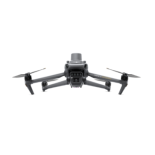
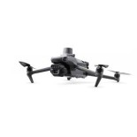
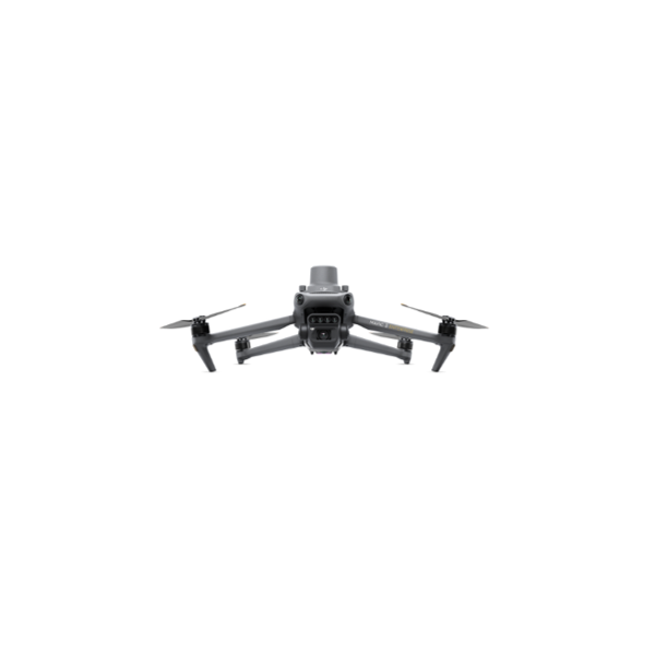
Here is the DJI Mavic 3M Multispectral. It is a professional drone designed for agriculture and environment. With its multispectral sensors and RGB camera, it is able to perform multispectral mapping.
The DJI M3M natively integrates the RTK module, which allows it to obtain positioning correction data. The geo-referencing of the acquired data is then centimeter accurate, and therefore the resulting actions and decisions are sure to reach their target.
Environmental specialists, farmers, agronomists or even chambers of agriculture will be able to obtain data on the state of their land, plants and other forms of plant life thanks to this device.
The RGB 4/3 sensor of the DJI M3M is 20 MP. It is excellent for photogrammetry, because of its mechanical shutter, a shutter speed of 1/2000s, and a burst of 0.7 seconds. The DJI Mavic 3M Enterprise's multispectral camera allows to visualize NDVI data & indices through various wavelengths (Green, Red, Red Edge, Near Infrared)
Secure and powerful, the DJI Mavic 3 Multispectral has OcuSync 3.0 (O3) which ensures a robust connection and a theoretical maximum flight range of 8 km. Also, it has an autonomy of 43 minutes which allows it to treat up to 2 km² of surface. With the help of its obstacle detectors, it actively avoids potentially dangerous objects for its flight, continuing its mission autonomously.
|
|---|---|
| Contents of the package |
|

No customer reviews for the moment.